   |
|||||||
Redistricting of School Board Member Voting Districts DOES NOT impact student attendance boundaries or transportation. |
|||||||
Click here to View Map AlternativesSchool Board Redistricting Map Alternatives(Redistricting Map Proposal Submittal and Review Process Flowchart) The School Board appointed Redistricting Steering Committee will review map options for the Broward County School Board to consider in the 2011-13 redistricting effort. Each option will be reviewed based on the School Board's Guiding Principles for drawing School Board districts. In addition, members of the public may submit alternative School Board district maps for the Redistricting Steering Committee to publicly discuss. The School Board Redistricting Steering Committee will review all maps submitted. You must email your final redistricting map(s) to redistricting@browardschools.com two weeks prior to a Steering Committee hearing for discussion at that hearing. Maps, Data, and Tools for DrawingIf you are interested in drawing a redistricting map for review, maps will be accepted in three formats:
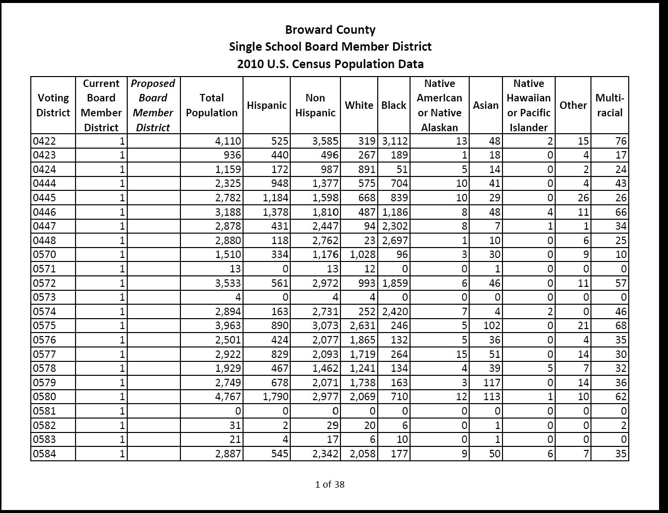
All of the map drawing methods listed above must use the 2010 U.S. Census data aggregated by voter tabulated districts to identify the geographical areas included in a new District map. All maps drawn will be reproduced and formatted by the District's Geographic Information System (GIS). District staff will do their best to translate any map submitted for review and cannot guarantee there will not be interpretation errors. 1. Paper Maps and Data Tables for creating mapsMaps and U.S Census 2010 population by voter tabulated districts are available in portable document format (PDF). "PDF" files can be viewed using free Adobe Acrobat Reader software from this web page as maps become available. You must email your final redistricting map(s) to redistricting@browardschools.com two weeks prior to a Steering Committee hearing for discussion at that hearing. 2. MyDistrictBuilder for creating mapsMyDistrictBuilder is a Web mapping application supported by the Florida House of Representatives for developing new congressional and legislative districts. Although MyDistrictBuilder software may be used to develop single School Board member districts, this was not the intended function of the software and as a result there are limitation to this software. Broward County Public Schools can not provide technical support for MyDistrictBuilder. All software code and data are the properties of the Florida House of Representatives and the U.S. Census Bureau. All technical questions with MyDistrictBuilder, the data contained within, and/or the use of MyDistrictBuilder should be directed to the Florida House of Representatives or the U.S. Census Bureau. For more information on how to use MyDistrictBuilder, please visit: http://mydistrictbuilder.wordpress.com/learnmydistrictbuilder/ . You will need the following 3 items to start building single School Board member districts in MyDistrictBuilder: 1. MyDistrictBuilder application: 2. To start building single School Board member Districts, you must unzip the following “.kmz” file to your local hard drive and then open the file in MyDistrictBuilder: SchoolBoardKMZ.zip 3. Instructions on How to Build School Board Member District Boundaries with MyDistrictBuilder. You must save your completed plan in MyDistrictBuilder as a ".kmz" file and email it to redistricting@browardschools.com two weeks prior to a Steering Committee hearing for discussion at that hearing. 3. Geographic Information System (GIS) for creating mapsThe following file is a compressed file (.zip) containing the voter tabulated districts with 2010 U.S. Census information, Broward County Public School locations, and the 2011-12 school boundaries in ESRI's shapefile format. For additional Broward County GIS data you may wish to use, visit: http://gis.broward.org/ Click here to download the GIS data: Redistricting Data.zip You must email your final redistricting map(s) and shapefiles to redistricting@browardschools.com two weeks prior to a Steering Committee hearing for discussion at that hearing. |
|||||||